|
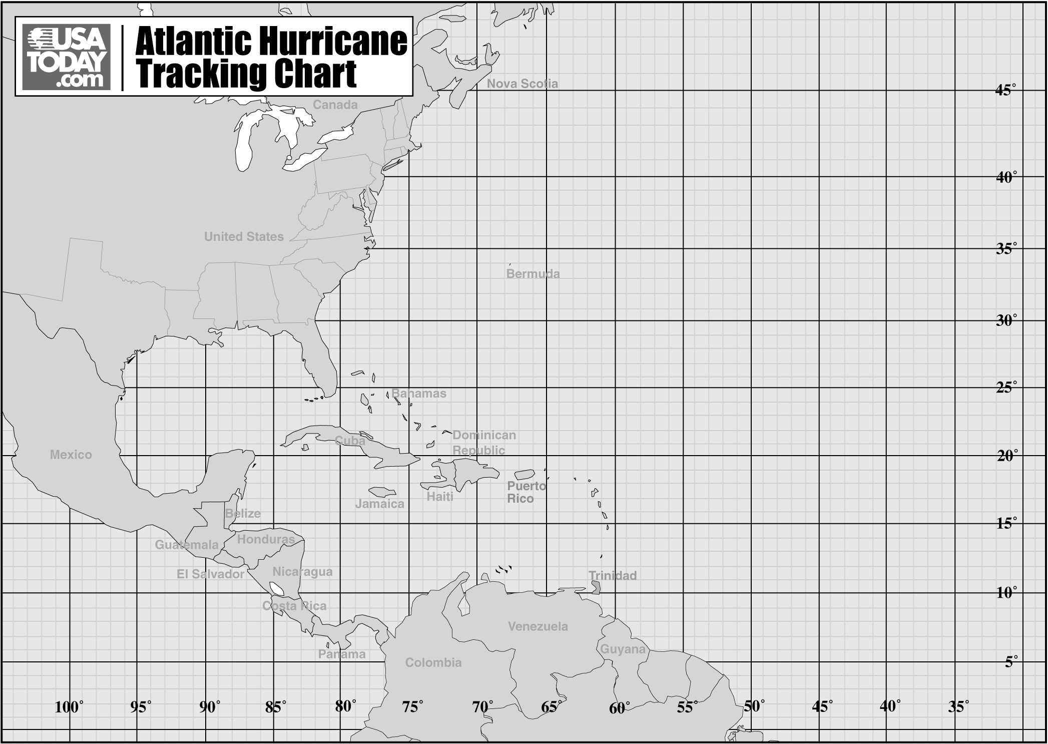
Latitude and Longitude (Hurricane Tracks) Lab Note: Remember you are responsible for graphs, charts and other items that form part of the overall summary of this topic. Background: Hurricanes are one of nature’s most powerful disasters. To equal the power of a hurricane, one would have to set off about a thousand nuclear devices per second for as long as the hurricane rages. While it is very difficult to predict where a hurricane will travel, this prediction is very important, especially if you are in its path. In this lab you will be plotting the path of some of the most deadly, devastating, recent hurricanes. You will be asked to analyze the strength of the hurricanes, compare their speed of travel, and their paths’ of destruction. "The greatest potential for loss of life related to a hurricane is from the storm surge." states Brian Jarvinen, from the National Hurricane Center. Storm surge is simply water that is pushed toward the shore by the force of the winds swirling around the storm. This advancing surge combines with the normal tides to create the hurricane storm tide, which can increase the mean water level 15 feet or more. In addition, wind driven waves are superimposed on the storm tide. This rise in water level can cause severe flooding in coastal areas, particularly when the storm tide coincides with the normal high tides. Being that much of the United States' densely populated Atlantic and Gulf Coast coastlines lie less than 10 feet above mean sea level, the danger from storm tides is tremendous. Directions: Plot the hurricanes’ paths using their latitude and longitude. Use a different colored pencil to mark the paths of the different hurricanes. Use the Saffir-Simpson scale to determine the category of the hurricane and answer the analysis and conclusion questions. Latitude and longitude are given in degrees and minutes (remember each degree can be divided into 60 minutes.) Saffir-Simpson Scale: The Saffir-Simpson Hurricane Scale is a 1-5 rating based on the hurricane's present intensity. This is used to give an estimate of the potential property damage and flooding expected along the coast from a hurricane landfall. Wind speed is the determining factor in the scale, as storm surge values are highly dependent on the slope of the continental shelf in the landfall region.
Hurricane Andrew (1992): Hurricane Andrew was one of the most destructive United States hurricane of record. It blasted its way across south Florida on August 24, 1992. NOAA's National Hurricane Center had a peak gust of 164 mph—measured 130 feet above the ground—while a 177 mph gust was measured at a private home. Andrew caused 23 deaths in the United States and three more in the Bahamas. The direct loss of life seems remarkably low considering the destruction caused by this hurricane. The hurricane caused $26.5 billion in damage in the United States, making Andrew the second most expensive natural disaster in U.S. history. Plot the following points as an X on your map; connect your points. Label the category of the storm. Note: readings taken every 12 hours.
Hurricane Jeanne (2004): Jeanne hit Florida after Hurricanes Charley, Frances, and Ivan. In six weeks these storms shut down much of the state and prompted recovery plans on a scale never before seen in the nation. Jeanne was blamed for at least six deaths in Florida. The storm had already cut a deadly path through the Caribbean, where floods in Haiti, the Dominican Republic and Puerto Rico killed over 3,000 people. Haiti suffered the heaviest toll. Two days of torrential rains caused massive flooding and mudslides in the northern region, killing close to 3,000 people. Plot the following points as an X on your map; connect your points with a different colored line. Label the category of the storm. Note: readings taken every 6 hours.
Hurricane Ernesto (2006): Remnants of this storm brought many Labor Day plans in the New York City region to a halt. Wind speeds of over 50 mph brought many trees and and limbs down causing massive power outages all along the South Shore of Long Island. Beach erosion hit Robert Moses State Park most severely, affecting nearly the entire beachfront. Sunken Meadow Park on the North Shore of Long Island, lost two to four feet of dunes. The wind pushed the sand up to the point where a lake, two to three feet deep, was created on Jones Beach near the West Bathhouse. At least six died in North Carolina and Virginia as the storm made its way up the Eastern Seaboard. Plot the following points as an X on your map; connect your points with a third color. Note: readings taken every 12 hours.
When plotting your points for the above hurricanes, please use the map below.
Analysis Questions 1. Mark the 30ºN Latitude line on your map. State the general direction that the storms moved below this line. What direction did the storms move above this line? 2. Go to page 14 of the ESRT. What is a likely reason for the general paths of the storms? 3. Cuba is 1,140km across. Create a scale for your map. Show your work. 4. Speed is distance divided by time. What was the average speed (not wind speed) of Hurricane Andrew between point #5 and point #11? Show your work. 5. What was the average speed of Ernesto between point #9 and point #19? Show your work. 6. Where are the storms when they had their strongest winds? 7. What happens to the wind speeds and intensity of the storm as they move over land? 8. Based on what you already know about seasons and hurricanes, make an inference about why most Hurricanes form in the months of July, August, and September. Remember that when writing up your lab report, you must follow the proper format. |